
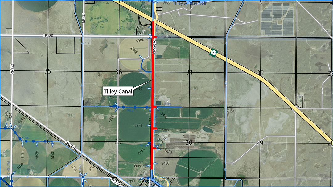
The Tilley Canal rehabilitation project is located between Hwy #1 and the Hamlet of Tilley, running adjacent to Sec Hwy #876 for 3.4 km. 12 pivots and 2 flood fields are directly served from this section of the canal, and 11,200 irrigation acres are served downstream. Most of this section of canal is in fill. The canal seeps into borrow pits beside the canal and the inside side slopes are steep, indicating that erosion has taken place. The proposed rehab is to line, armour, and restore the freeboard of the canal, which will stop seepage and increase the canal’s durability. As well, 5 deliveries that cross Hwy #876 will have the culverts converted to pipe. The project is slated for the 2026/2027 construction year at an estimated cost of $5,336,000; to be funded under the AIM program.
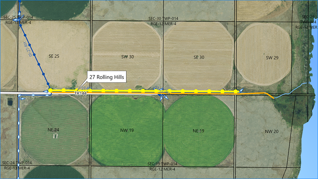
The 27 Rolling Hills rehabilitation project is located 11 km south of Rolling Hills, serving 5 pivots totalling 678 acres of irrigation. The existing canal is unlined, unarmoured, and in poor condition. The rehab will install 2.1 km of closed gravity pipeline, install a gabion wall to the existing pond, convert 2 km of the canal to a drain, and rehab ½ km of drain. The project is slated for the 2026/2027 construction year at an estimated cost of $2,190,000; to be funded under the AIM program.
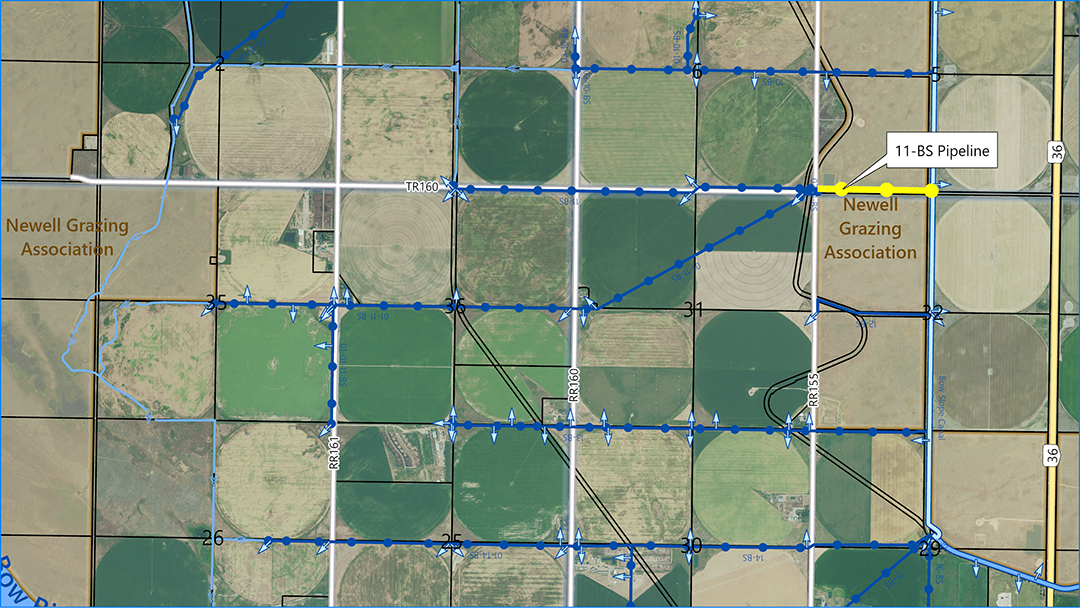
The 11 Bow Slope rehabilitation project is 3.2 km north of Scandia and 800 m west of Hwy #36, serving 1,864 pivot irrigation acres. The existing canal is unlined, unarmoured, and in poor condition. It is also a level bank ditch and is often operated above its FSL, making it short of freeboard. The 48” diameter pipeline will be 800 m long and will tie into 2 existing pipelines. A settling pond with gabion wall will be installed at the start of the project and the existing pond to the west will be filled in as material is available. The project is slated for the 2026/2027 construction year at an estimated cost of $1,420,000; to be funded under the IRP program.
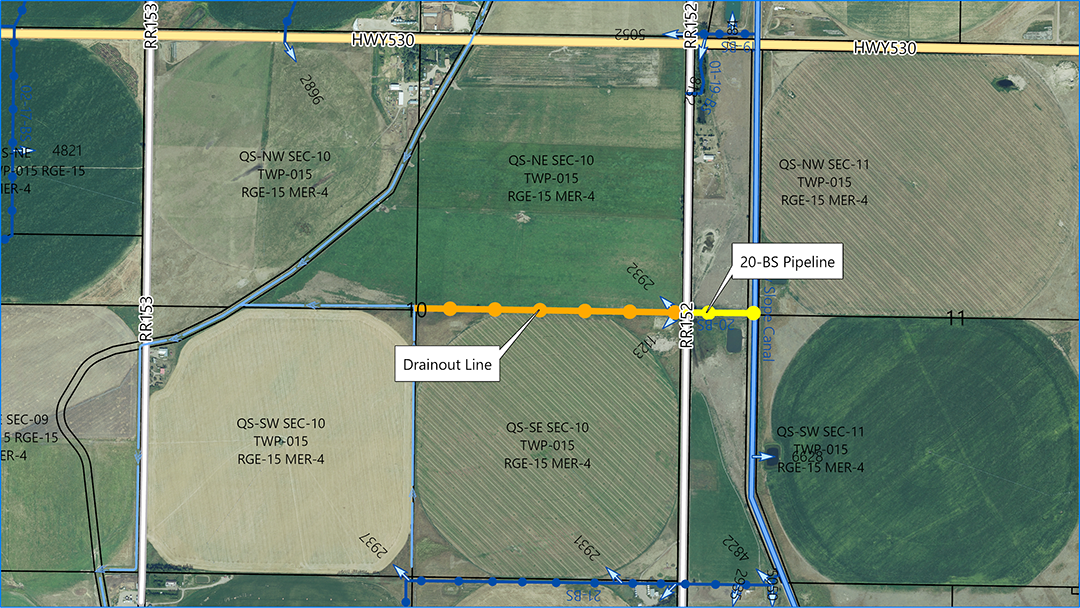
The 20 Bow Slope rehabilitation project is approximately 6 km southeast of Scandia, just south of Sec Hwy #530, serving 154 flood acres. The existing canal is overgrown with vegetation and backs up the water, impacting the ability to supply. The rehab will consist of installing a 24” diameter closed gravity pipeline to supply 6 cfs, extended by a 10” diameter drain out. The project is slated for the 2026/2027 construction year at an estimated cost of $392,000; to be funded under the AIM program.
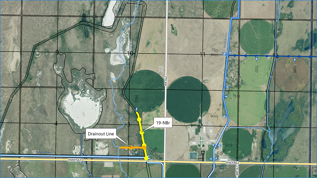
The 19 North Branch rehabilitation project is approximately 7 km northeast of Gem, serving 424 pivot irrigation acres. The existing canal is overgrown with vegetation, impacting capacity. The rehab will consist of installing a 24” diameter closed gravity pipeline, stilling pond with gabion wall, and a lateral 6” diameter drain out. The project is slated for the 2026/2027 construction year at an estimated cost of $901,000; to be funded under the Capital Works program.
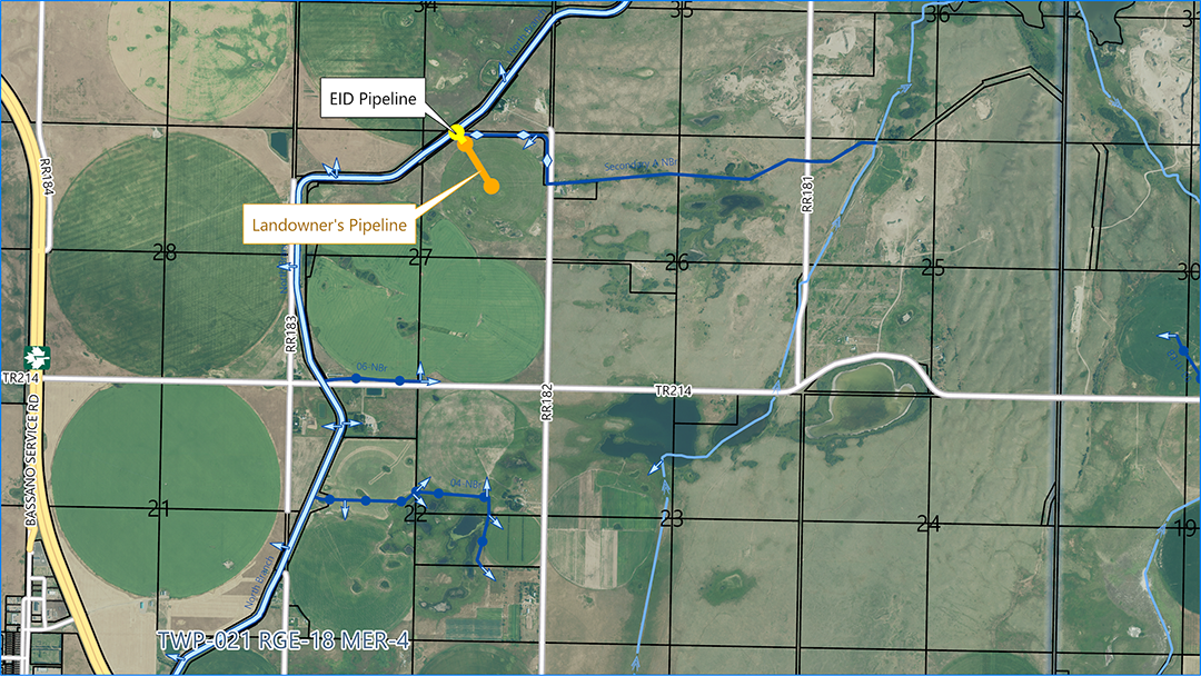
The Secondary A North Branch rehabilitation project is approximately 5 km northeast of Bassano and will have the capacity to supply 9 cfs for 3 quarter section pivots with corner arms. Rather than rehabilitating the full length of the existing ditch to the current delivery, the landowner has agreed to move her delivery to the pivot center in NE 27-21-18 W4M. Moving the delivery point saves the District $160,000 in pipe and in turn enables an Infrastructure Cost-Savings Grant to be provided to the landowner. As the District will not be able to drain this portion of the pipeline, this portion of the infrastructure will be turned over to the landowner for ownership and full maintenance responsibility. This project is slated for the 2026/2027 construction year at an estimated cost of $542,000; to be funded under the AIM program.
The Environmental Impact Assessment (EIA) for the Snake Lake Reservoir expansion project has been completed, 22 individual sections have been written to evaluate the existing conditions and to define the environmental impacts of building the reservoir. All sections have been reviewed and finalized by third party engineers, consultants, and the EID. Technical documents have also been developed to assist in the design of the reservoir and include detailed investigations of the ground conditions under the proposed dam, the ground conditions within the reservoir where the borrow material will be excavated, the impacts of major storm events on the expanded reservoir, the impacts of a dam breach on the downstream lands and infrastructure, a preliminary investigation into a new outlet structure with increased capacity, and investigations into riprap and filter sand supply and transport to site. The EIA was submitted to Alberta Environment and Protected Areas (AEPA) on April 2nd. Following submission to AEPA, the document will be reviewed for completeness and to ensure it meets the Final Terms of Reference. The Natural Resources Conservation Board (NRCB) will also review the submission. AEPA will also require approval under the Alberta Water Act prior to construction. It is expected that approvals will take a minimum of 1 year.
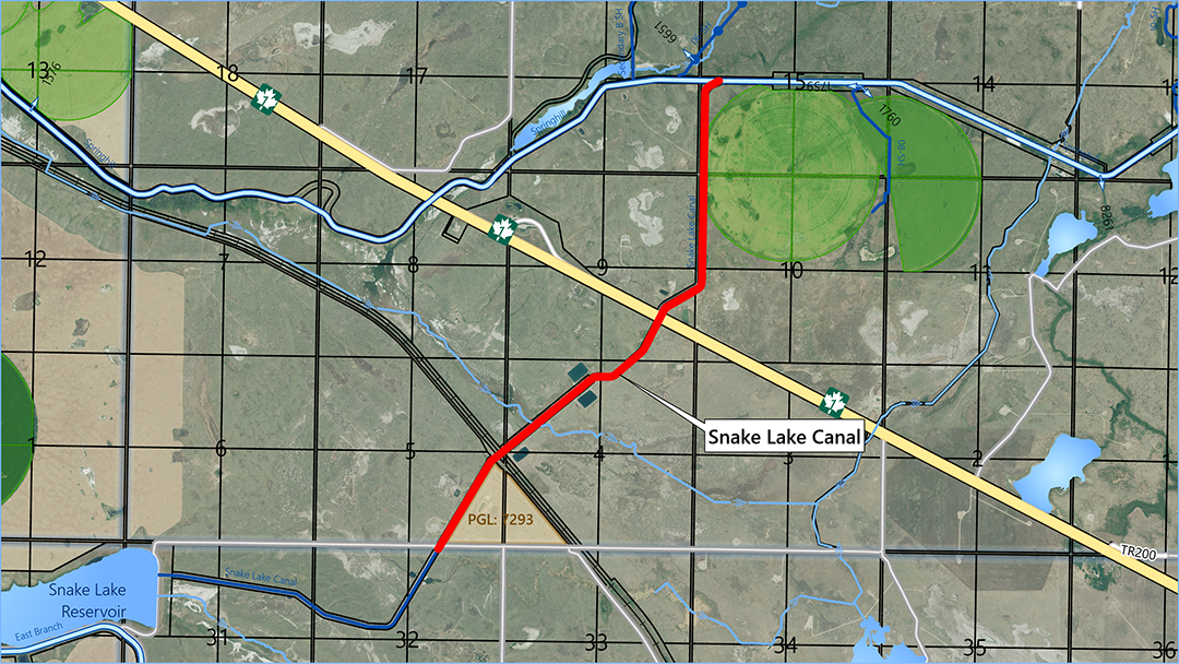
The Snake Lake Canal rehab project was approved at the June 24, 2025, EID Board Meeting. The 300 cfs canal starts at the east dam of the existing reservoir and runs east and north under the CPR tracks and Trans Canada Highway, delivering into the Springhill Canal. Part of the expansion plan for the Snake Lake Reservoir is to upgrade the Snake Lake Canal to 800 cfs to be able to supply the +50,000 downstream irrigation acres when the reservoir is completed. The rehabilitation consists of widening the canal on the 5 km stretch outside the expanded reservoir footprint, installing gravel armour, upgrading the concrete syphon at the tracks, and open-cutting across the highway to install a concrete pipe, all to handle the increased flow. This project will be funded under the IRP program for an estimated cost of $19,500,000; to begin construction in late summer or fall of 2025.
The EID and the Hutterian Brethren of Bow City executed a purchase agreement dated February 18, 2025, for the purchase by EID of approximately 372.60 acres of land located within SE 11, E ½ 02, E ½ 01-18-18 W4M and Pt of NW, NE & SE 36-17-18 W4M. Gravel deposits on the purchased lands will support the construction, operation, and maintenance of the Snake Lake Reservoir Expansion and/or other EID projects.
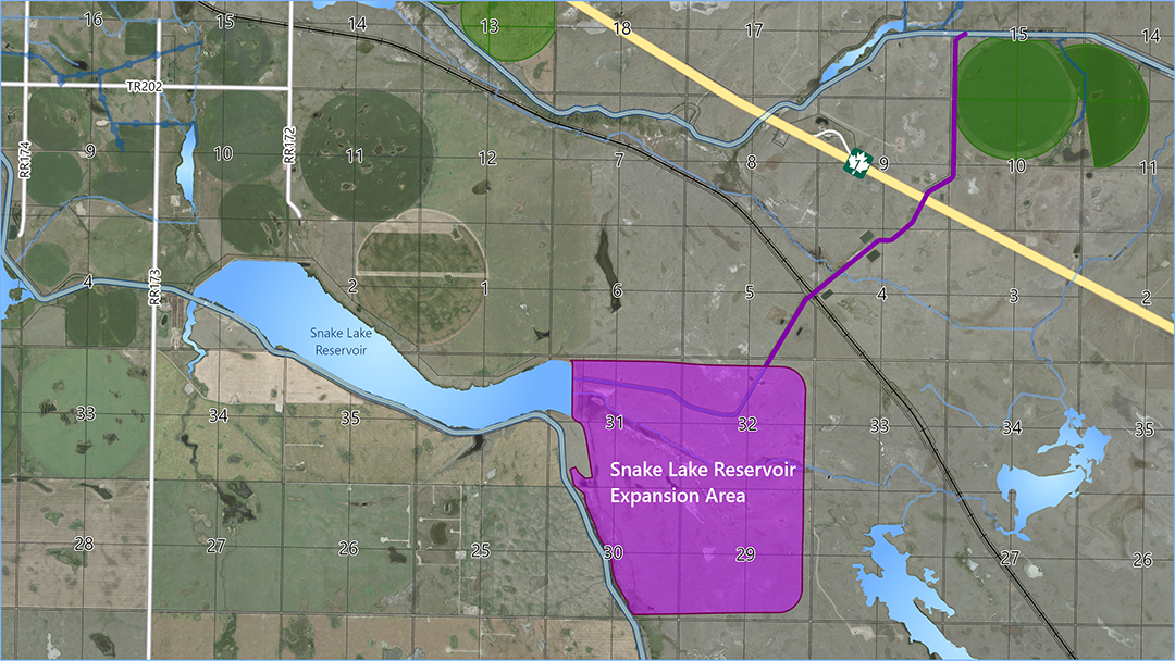
The 300 cfs Snake Lake Canal starts at the east dam of the existing reservoir and runs east and north under the CPR tracks and Trans Canada Highway, delivering into the Springhill Canal. Part of the expansion plan for the Snake Lake Reservoir is to upgrade the Snake Lake Canal to 800 cfs to be able to supply the +50,000 downstream irrigation acres when the reservoir is completed. The rehabilitation consists of widening the canal on the 5 km stretch outside the expanded reservoir footprint, installing gravel armour, upgrading the concrete syphon at the tracks, and open-cutting across the highway to install a concrete pipe, all to handle the increased flow. This project will be funded under the IRP program for an estimated cost of $19,500,000; to begin construction in late summer or fall of 2025.
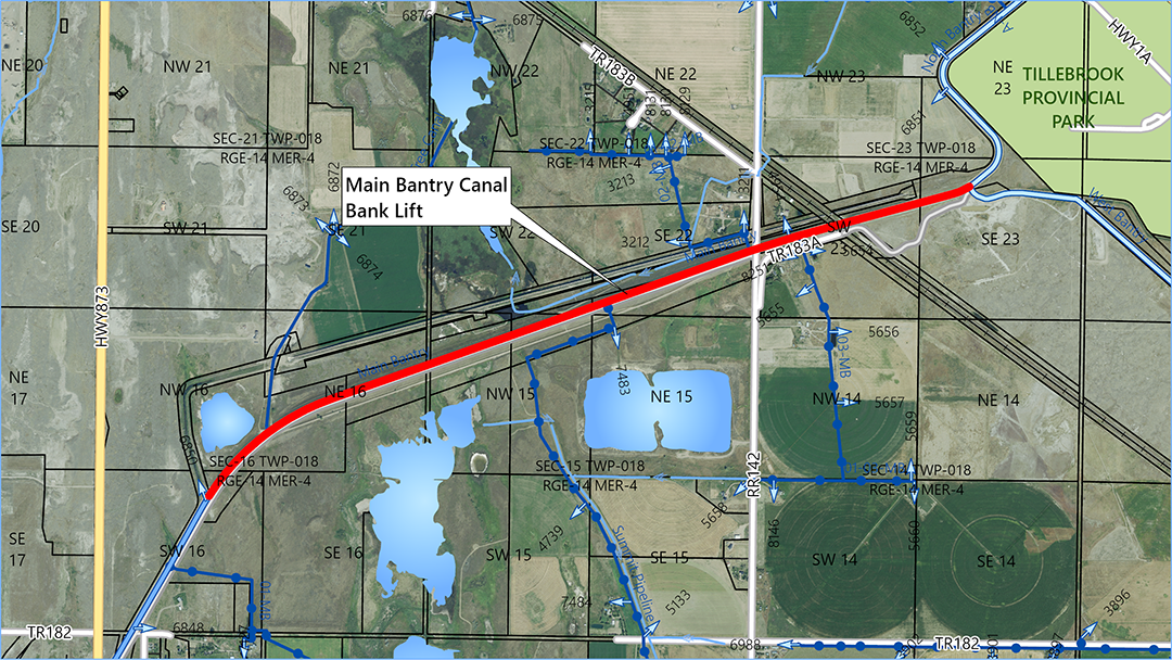
The Main Bantry Canal supplies water from Lake Newell Reservoir to Rolling Hills, Tilley, One Tree, and Patricia areas. The earthen Brooks Aqueduct, which replaced the concrete aqueduct in 1978, allows the EID to get water across a low area to these regions. The earthen aqueduct is 4 km long, includes a syphon under a railway, and has a capacity of 950 cfs. Although the canal was designed with a maximum height of 16 m it has settled up to 50 cm over the past near-50 years. While it is currently possible to convey 950 cfs there would only be 40 cm of freeboard instead of the designed 90 cm. The rehab project will increase the height of the banks with clay material and add armour at an estimated cost of $708,000 to be funded under the Capital Works program.